Top 6 Hikes from the Vienna Woods: Favorites from an IES Abroad Alum

ies abroad logo
IES Abroad
4 studends are walking in the field going into Vienna Woods

Want to learn about the best hikes near Austria's capital city? We turned to avid hiker Robert Juppe (IES Abroad Vienna, Academic Year 1980-81) to get the scoop on his top six hikes (and where to get the best glasses of wine after!) in the Vienna Woods. Bob will lead a walking tour in the Vienna Woods at the 70th anniversary IES Abroad Vienna Weekend!

Whether you are studying abroad in Vienna or traveling through Austria, check out these tips for some great trails about an hour drive outside of Vienna.

A photo of an old town of Vienna

Those who underwent the IES Abroad Vienna Center orientation in the 1980s might recall hearing those lines from Dr. Lonnie Johnson. (If my memory serves correctly, he was quoting the German composer Johannes Brahms.) How did the quote apply to Vienna in the 1980s? Perhaps it illustrated that Vienna still retained a certain charm and unhurried pace of life even as the frenetic 1980s unfolded. On the other hand, it might have also served to draw attention to a form of cultural/societal obstinacy, one that seemed to prevent Vienna from blossoming into a dynamic urban center as the 20th century came to a close. Regardless, the quotation could be called prescient, as Vienna has come to frequently capture a ranking of number one as the world’s most livable city in a number of global surveys taken in the past two decades. Apparently, the charm has prevailed. Relative to the second interpretation of that quotation, one could ask how Vienna has fared during the decades since those orientation lectures.

Walking down the Karntnerstrasse or the Graben, or gazing out from the summit of Kahlenberg (Leopoldsberg is now in private hands, but one can still walk this final Alp’s perimeter), two of the great changes that have occurred in the city during the past 40 years become evident: One, the city has become extremely crowded, particularly with tourists, and, two, it has grown wildly, especially those districts that have expanded outward from the city center to the west from Schönbrunn and to the previously empty regions far east of the Danube. One wonders what Dr. Johnson would make of Vienna’s transformation given its earlier ostensible resistance to change. 

The foresight of Emperor Franz Josef in augmenting the magnificence of the Innere Stadt (Inner City, or Old Town of Vienna) should command respect today. It seems the city will never suffer a shortage of tourists thanks to this opulent investment. However, the foresight of two other historical figures, Josef Schöffel and Dr. Karl Lueger, might be less noticeable to the average visitor. These two men, each in his own way, strove to preserve the green belt encircling the city, known to most as the Wienerwald, or the Vienna Woods. (Note: Lueger, as mayor, was instrumental in pushing through the 1905 decree protecting the Vienna Woods. Schöffel, who now has a peak in the Wienerwald named for him, served as a one-man lobbying bulwark to prevent logging interests from decimating the Vienna Woods.)

Hiking the Vienna Woods is truly for everyone. There are short jaunts and excursions near the city; the longest, on the other hand, is the Rundumatum, which is actually comprised of two hiking routes, the longer being roughly 145 km, the shorter being 120. Both of them start at the northernmost hill of the Vienna Woods, Leopoldsberg, and end on Elisabethhohe (358 meters) on the Bisamberg on the other side of the Danube. As the name indicates in German, both encircle the city completely.

In the essay that follows, six Vienna-area hikes will be covered, while a seventh will be outlined briefly in the article’s final recommendations:

  1. The Helenental
  2. Leopoldsberg-Purkersdorf
  3. Kreuzenstein-Michelberg-Stockerau
  4. Klosterneuburg-Greifenstein
  5. The Bisamberg
  6. The Big Boys 
The view of the Helenental

1. The Helenental

The southern section of the Vienna Woods, a hike starting from either Baden or Baden Voslau stations on the Schnellbahn.

Starting Point: 

  • Option 1: Baden Station (Schnellbahn from Wien Mitte/Liesing/Rennweg; one can also take the Lokalbahn from the State Opera House, which is a pleasant, 62-minute ride.)
  • Option 2: Continue on the Schnellbahn (which is not very schnell at times; it has been late several times when I have taken it during the past decade) to Baden Vöslau.

Time: Allow six to seven hours for this hike regardless of the starting point.

Overview: While this hike is not particularly difficult, it includes one or two steep grades. Walk through the park to the right of the station exit, the west side, and head for downtown Baden. Pass the Bank of Austria in the center of the town, then keep to the red-marked poles/trees. Eventually you will pass under a high aqueduct. Be forewarned that it will take roughly 25-35 minutes to reach the actual course. 

The course starts on a combination bike path/hiking course. When you come to the first bridge to cross over the Schwechat River, do not follow the trail, but go instead to the right. It should be added here that the Schwechat River has lent its name to both the popular beer that could be Austria’s Miller High Life or Budweiser counterpart, and of course, the airport. The Church of St. Helena is there, but more importantly, high above looms the ruins of Rauhenstein (built in the 12th century), upon which you will surely want to spend 30-45 minutes exploring and scrambling. Though the official signs read DO NOT ENTER, there is a contradictory sign at the front that reads BETRETEN AUF EIGENE GEFAHR ("Enter at your own risk"). Follow the advice of this sign, and if you are going to picnic here, the high turret is an ideal spot to do it. You will have a commanding view of Baden, the hills stretching to the west, the small town below, and Rauheneck on the other side, an even smaller ruin. Note that both were once great castles, but they fell to one of the Turkish sieges. (The specific siege was not given on the sign outside of the castle.)

The ruins of Rauhenstein hold yet more historical significance. In 1809, too, it was said that Napoleon visited the Helental and was impressed by its beauty. He boasted that he might one day retire to the valley of St. Helena. The great irony being, of course, that he was exiled to the island of St. Helena, not the valley in Baden.   

Not long after Napoleon passed through, Beethoven’s nephew Carl pawned his watch, bought two pistols, and attempted suicide atop Rauhenstein in 1826. Luckily, neither bullet penetrated Carl’s skull; his influential uncle later helped him get into the army.

Hiking up the Schwechat River, you will eventually come to the Beethoven Stone. It is written that the great composer often rested there on hikes between 1824 and 1826. Don’t spend too much time on the bench there, however; you will still need to walk about 800 meters to the Steiniger Weg. This will take you up, up, up, but the views at the top will definitely be worth it.  Not only will you see Baden, but Vienna far, far beyond the hills. Note that while the grade is steep, the climb is not particularly difficult.

Go all the way to the top of Hoherkogel, where you will find Eisernes Tor, the perfect place for a 30-minute break and an Ottakringer vom Fass. (A draft Ottakringer. This will definitely beat a draft Bud or Miller High Life, walk or no walk.) Food is served there as well, and there is a tower that you can climb for a view of the opposite side, the area to the south of Baden, free of charge.

Head down the red trail in the direction of Baden. The path is well-marked. You will then come to a trail with a blue marker, and one with red. Either one will take you to the bottom; either will take you back to the entrance under the aqueduct. From there, you will easily find your way back to the train station. As most of you will remember from practicing German with Viennese war widows in the 1980s, they love the expression, Alle Wege führen nach Rom! ("All roads lead to Rome!") (You might find this apocryphal, but in Stammersdorf, when asking for directions to a wine garden, an elderly woman on the street actually used this expression…in March, 2019.)

If you start this hike from Bad Vöslau, follow the Harzberg Strecke. You will be rewarded with stunning views from rock cliffs high above Lower Austria. If you then follow the signs, you will eventually wind up at Eisernes Tor, and you can then follow the same directions down as if you had started out from Baden. If you do go this way, however, you might miss Rauhenstein. It is possible to catch both, though, if you choose to return from Baden Station after starting from Bad Vöslau. You would merely have to go left at the bottom of the trail that returns you to Baden Station rather than the quicker right turn. This might add an hour to the proposed time frame, but as I wrote earlier, it would be worth it.  

a view north from hoherkogel in the Helental

2. Leopoldsberg-Purkersdorf

The first segment of the circular hike around Vienna, a hike that can start from a number of points depending on one’s enthusiasm for exercise.

Starting Point: The bus stop along the main thoroughfare in Kahlenberger Dorf, which looks onto the Danube, would be a great starting point, as you are within a couple hundred meters of the Nasenweg. Another option is to start walking from the end station of the D tram to Nussdorf, which will add a couple of hours to the hike. Finally, you could go to Grinzing and catch bus 38A, which will take you directly to Leopoldsberg. It is a pleasant ride, and all of it would be included in your transportation pass. 

I should mention here that with any of the hikes outside of the borders of Vienna proper, you should buy a Schnellbahn ticket from the Stadtsgrenze, as your Vienna pass is valid up to the city’s boundaries.

Time: Six to seven hours. (NOTE: It is possible to abandon this hike at any point and wander down into one of Vienna’s outlying 17th, 18th, or 19th districts. In other words, this hike could be anywhere from 2-4 hours as well.) 

Overview: Just head along the road and look up. You will come to a trail known as “The Nose.” (Nasenweg). It is a very steep path, but well laid out. It has probably been there more than 200 years, as it was constructed by Prince Charles Joseph de Ligne, who was also the source of the famous quote, when asked about how the Congress of Vienna was going, “The Congress isn’t going much, it dances.” (That comes from one of my delightful IES Abroad history lessons in 1981.) 

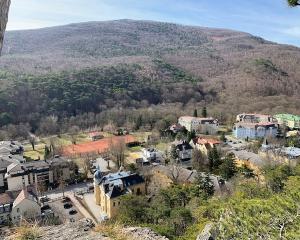
At the top, you will be able to enjoy the views of Vienna and the surrounding areas north and east of the city, the Danube included, from Leopoldsberg. It is not possible to enter the castle any longer, but you can circumnavigate its exterior. Continue on past Kahlenberg, where you can also enjoy the views and stop by the church that Jan Sobieski is said to have prayed in before saving Vienna with his army during the Ottoman siege of 1683.

When looking down upon the rows and rows of vineyards, it should be noted that Vienna is number one in the world for wine grown within its city limits. Other cities may grow more in and around their areas proper, but Vienna ranks one for growing loads of grapes within the city limits. This is a fact to rival the one Lonnie Johnson delivered in his orientation lecture in 1980-81: The Viennese were number one in the world for sugar consumption. (Perhaps he said Austrians; some things are hard to recall after 40 years.)  

Continue on for another hour or so, and you will reach Hermannskogel. Climb up to the Habsburgwarte, a delightful little church high above the city. The views are terrific, and this is a good place to sit and have a break. Be forewarned that during the next hour, you will encounter at least three Gasthauser. I am partial to Hauserl am Roan, which features outstanding pork and beef dishes from local suppliers. Oddly, the smoking room has the best views. Remember I mentioned Austrian obstinacy? The modern day Gasthaus has provided a non-smoking area, but often, the back is where you will find it. The front, especially in this establishment, has the better views, the better seats, the better lighting, and the tobacco smoke that many IES Abroad students may look upon as nostalgic from bygone years. 

You can choose to end this hike soon by heading down into Neustift am Walde, or you can plunge into some fairly deep woods that will begin taking you out of the city. You will pass fields, meadows, and even a small ski slope with a lift, all of which give you the feeling that you are far, far from the city…when in fact, you are not. Just walk to a bus stop and presto, you will be back at a streetcar appendage that will return you to the city center in due time. 

Purkersdorf is a fairly large town if you are able to hike this trail to its terminus (terminus as decided by me). From there, you can catch a Schnellbahn back to the city. It should be noted that the headquarters of the Vienna Woods is located here, not surprisingly, in a very small office on the Hauptplatz. 

Variation: Instead of sticking to the red trail away from Kahlenberg, take the alternate trail down to Klosterneuburg. This will take you no more than an hour. The cloister is worth an extensive tour, and actually, joining a proper tour here is a good idea. (It will serve as a delightful brush-up of your German skills.) Signs from Kahlenberg will point you in the direction of the town. 

Here I should note that you will want to pick up a Kompass Wander und Bikekarte (Wien und Umgebung). It provides two maps of the city and all of its trails in minute detail. It is indispensable if you don’t want to get lost…and with this, you can be sure that you won’t get lost…not too often, at any rate.  

3. Kreuzenstein-Michelberg-Stockerau

Technically not a Vienna Woods hike, but near enough to the city to count. This hike could commence from Burg Kreuzenstein Station on the Schnellbahn as well.

Starting Point: Schnellbahn Station Leobendorf Burg Kreuzenstein.

Time: Six to seven hours. (Shorter if you take a bus from Leitzersdorf, Haselbach, or Niederhollabrunn, all towns at the base of Michelberg.)

Overview: Head out toward the main road, cross it, and keep walking into the town. At the hotel, turn left. Start walking up. A well-marked trail will appear on your right. You can take this up through the woods to the castle rather than walking along the road. Keep in mind that from here, all roads will lead to Burg Kreuzenstein (all headed up, that is). 

If the castle at Kreuzenstein is open, stop for a rest here. There is a restaurant with a commanding view of Klosterneuburg and the area stretching north to the Danube. If you have time, a tour of the castle is enjoyable as well. Tours are in German only. It is, however, a beautiful castle that was cobbled together with the remains of other castles from around the area, which makes it both a neo-medieval structure, as well as an original medieval structure. (Did that make sense?) It is striking in its location; it should be noted that there had been another castle on the site from centuries before. 

Leave the castle through its back parking lot. It is there that you will find a trail marked in red. Take this into the woods and head east. It will take you over another busy road and then up through verdant fields. After passing these, the trail heads into thick woods. Before going in, however, you should stop to have a look at the commanding view of Vienna, Klosterneuburg, and the Bisamberg. If you are blessed with a clear day, the view will be breathtaking. There is a bench conveniently placed there for enjoying the view, and perhaps, a bite to eat. 

After walking for 45 minutes or so, you will come to a lovely looking Gasthaus, the Goldenes Brundl. It has been either closed or full when I have passed through, but it looks to be very good. After reaching this restaurant, head for the path across the street marked in green, the H. Czettal Rundwanderweg. This will take you through lovely woods and eventually up to the top of Michelberg.

From Michelberg, you will have a commanding view of northern Austria, and the area stretching clear to the Czech border. The little towns of Niederhollabrun, Karnabrunn, and Weinsteig dot the expansive plane stretching back. Plan on spending at least 30-40 minutes up on this windswept mountain top. There is a tiny church there as well. It is one of the most popular views in this area, as it is the highest peak in the Rohrwald Hills at 409 meters.

Follow the red trail down the mountain. It is a lovely walk into the town of Leitzersdorf. From there, you can shave a good hour off of this walk by taking a bus into Stockerau, or you can choose to traverse the huge fields that lie between Stockerau and Leitzersdorf. There is a pedestrian path cutting through the field just to the left of the main road as you exit Leitzersdorf. You should have no trouble finding it, as it is clearly marked in red. 

Stockerau is a lovely town that is full of good restaurants and shops. Here you can celebrate a long hike completed and then head back to Vienna on a Schnellbahn. I found a wonderful old Gasthaus serving Hirschragout (venison stew) that coupled beautifully with a hearty glass of St. Laurent, which I discovered years later to be astonishingly similar in both body and finish to a good pinot noir.  The station is located in the center of the town. It should be no trouble finding it. Remember that all roads lead to something? That applies here again. 

4. Klosterneuburg-Greifenstein

The northern section of the Vienna Woods, on the northern side of Kahlenberg.

Starting Point: There are several options for this hike. Perhaps the best would be going to the end terminus of the 41 A bus line (Neustift am Walde) or the 43 B in Neuwaldegg. In either case, walk west and look for the red trail once you are in the woods. 

Time: Five to six hours.

Overview: Once you are in the woods, start heading in the direction of one of these towns: Oberkirchback, Unterkirchback, or Hintersdorf. The woods here are beautiful and were reputedly a favorite place for Franz Kafka to hike during the time he spent in Vienna.  Curiously, as his health was not too good, one wonders just how much hiking he did here. 

The only one of these towns that you will actually pass through is Hintersdorf. You could skirt it by sticking on the trail that carries you in the direction of Kierling, which is where Kafka spent his final days before passing away. The sanatorium on Hauptstrasse is marked with a plague, though it is hard to catch, as the building is now a three-story flat. You will have no trouble picking the trail up; this will then take you over the hills into the thick woods of Heuberg. 

The castle at Greifenstein is worth a look around. The ruins are not accessible, but the castle itself is stunning. It overlooks the Danube following its turn to the left upon departing Klosterneuburg. After wandering down to the main road along the Danube, you will find some tempting-looking Gasthäuser/restaurants, and then have your choice of heading left or right to one of two Schnellbahn stations that should be more or less equidistant, depending upon where you come out. 

Though this hike would seem to touch some very bustling suburban areas above Klosterneuburg, it is surprisingly hidden away among the hills and trees. Seldom will you feel that a large city and some of its suburbs lie all about. It is a well-plotted trail. 

a view from top of elisabethhohe on the bisamberg and danube

5. The Bisamberg

Again, this is technically not the Vienna Woods, but had the Danube never cut through this part of Austria, it probably would be linked to the range. Moreover, it can be reached easily by public transportation, perhaps more easily than many of the true Vienna Woods walks.

Starting Point: Langenzersdorf Schnellbahn Station would be ideal. Another option is Bisamberg. In either case, head for the red trail. It is marked well. 

Time: Two to four hours, depending on where you end up.

Overview: I am going to be perfectly honest and tell you that this is my favorite hike only because it has a personal connection. I lived in Strebersdorf and wandered up into these hills practically every Sunday afternoon. I encourage you to make it to the Magdelenenhof Gasthaus, as well. As a student, I nursed mugs of Gluhwein there. Today, you will get good boar or venison dishes depending upon when you go. It is definitely worth a stop; lunch is recommended. 

Regardless of which starting point you select, head for Elisabethhohe first. This will offer you a sensational view of Klosterneuburg, which is directly across the Danube, as well as Leopoldsberg and all of Vienna beyond. There is a grassy field on top of the mountain and a playground, as well as some benches. It would be a sensational picnic spot; you could still fit in a draft beer or a glass of wine at the Magdelenenhof. (At my age, I am avoiding the pastries…which are available, as well.)

After descending east from Elisabethhohe, head for either the Magdelenehof or straight across in the direction of Stammersdorf. The walk here is fairly easy, as the path traverses thick woods. You will eventually descend through wine fields, cross a road, and then take Stadtwanderweg 5 through the woods in the direction of Stammersdorf. There is a wonderful view of the plain stretching out toward the Slovakian border; years ago, it was an untrammeled vista. Now it is heavily spiced with windmills. In any case, it is still an outstanding view.

The path will carry you down from the woods into the little Heurigen town of Stammersdorf. This village is not only quaint, it is expansive. Take a long walk down Stammersdorfer Strasse and stop in one of the Heurigen for a rest. My personal favorite is Gerhard Klager Weingut located at Stammersdorfer Strasse 14. Be sure to try a glass of Blaufränkisch if there is any in stock at the time you visit. Along with Zweigelt, these are wines you will never find outside of Austria. Blaufränkisch is similar to a deep merlot in body and character though it is also close to a Barberesco or Barolo (somewhere in the middle of the lot). The restaurant is cozy, but again, be forewarned that smokers get the front, non-smokers the back. Willkommen zurück in Österreich!

A 15-minute walk down the road will take you to the Stammersdorf streetcar terminus. Be forewarned that the streetcars are not as slow as they used to be. This one will have you back in Vienna in 25 minutes, 30 at most. You can also get off at Floridsdorf and change to the U6 Line, one that did not exist for students in the 1980s. The U-bahn lines, along with the population, have grown as well.

6. The Big Boys

As mentioned earlier, the two circular hikes, Rundumatum. Any of the segments comprising these courses would prove delightful, but for a Vienna Woods section, the second segment, from Purkersdorf to Liesing might be the most scenic. After that, it becomes semi-urban, and once again, the walk does not actually take place in the Vienna Woods.

Starting Point (or Ending Point, depending upon your direction): Leopoldsberg or Bisamberg.

Time: Five to six days

Overview: Basically, both of these paths will take you all the way around Vienna. Both are well-marked, but be advised that around Liesing and the districts east, the trail can become hard to follow. For example, the map led me to a bridge over the New Danube that no longer existed; it took me hours to find a detour, traverse the river, and get back on track. 

The first two segments, in the west, are the prettiest and actually stay for most of the time in the woods. Three days should suffice for these, though an assiduous walker could complete the segments in two. The southern-eastern section is primarily urban/suburban, though the trail will masterfully take you through large parks, the Lobau (a nature preserve), and isolated areas in the eastern section of the city. 

The great part about this hike is that public transportation allows you to stop at one point, return to the city, and pick up where you left behind on the following day.

Recommended:


  1. Have a Netzkarte for the public transportation. This will you unlimited access to buses, trams, subways, and Schnellbahn within the city limits of Vienna.
  2. KOMPASS Kartenblatt 1 and 2 (Mentioned earlier in this article). This is a packet containing two maps of the city. Both are extensively detailed and include suburban areas outside of the city. They will be helpful in getting you both to your hikes and to your final goal.
  3. If sampling good wine is one of your aims, you might also want to consider this hike: Mannersdorf-Purbach (situated on Neusiedler See). Take the train to Götzendorf, switch to a bus bound for Mannersdorf, and then head for the hills. There is a well-marked trail heading up into the hills from Jägerhof. The hike is fairly uneventful, but very pleasant and with few difficult slopes. At the end, in Purbach, you will find loads of good eating/drinking establishments. The wine is terrific, as that region is well-known for its whites (Grüner Veltliner). However, I have found sensational glasses of both Zweigelt and Blaufränkisch here. To return to Vienna, take a Schnellbahn from Purbach to Neusiedl, then change for a Vienna bound train there.
  4. When in doubt concerning directions, ask. On all of these hikes, you are certain to pass other hikers. Confirm directions with them. It will give you a good chance to brush up on your German, especially if you approach older Austrians. (Some things never change.) 
Robert (Bob) Juppe (picture left circle)

Meet the Contributors:

Author: Robert (Bob) Juppe (pictured left) has been living in Japan for several decades. He teaches at a university there. He also writes texts and magazine articles. He studied abroad with IES Abroad Vienna at the Palais Kinsky during the Academic Year 1980-81 and served as Student Assistant from 1984-85 again in the Vienna Center.

Photographer: Al La Garde is a TV producer. He and Bob met on a connecting flight from Chicago to New York in December 1982, and they became fast friends. His father gave Bob a ride home from Kennedy Airport to New Jersey. After their hikes together in March 2019, Al did not give Bob a ride to Schwechat Airport.

Photographer: Al La Garde is a TV producer. He and Bob met on a connecting flight from Chicago to New York in December 1982, and they became fast friends. His father gave Bob a ride home from Kennedy Airport to New Jersey. After their hikes together in March 2019, Al did not give Bob a ride to Schwechat Airport.

IES Abroad News

Read More

IES Abroad regularly publishes news stories, articles, student stories, and other helpful study abroad content. Stay up to date on the latest from IES Abroad by reading our recent posts.

View All IES Abroad News